Showing posts with label trekking. Show all posts

Monday, October 13, 2014

Hiking Adam’s Peak in Sri Lanka

Adam's Peak on a clear day -- not the day we went (Photo from Wiki)

My main reason for coming to Sri Lanka had nothing to do with elephants (they were an unexpected perk). My main reason was Adam’s Peak.


Me at the start of the 5,200 stairs wearing my $4 rain jacket (bonus!)
What? You’ve never heard of it? Well, me neither…until I did a Google search on “what to do in Sri Lanka.” And there is was. Adam’s Peak. This majestic mountain is full of history and was there waiting for me to climb.

 I mentioned it to my friend Christine in Houston and she was instantly up for the challenge. What’s amazing about Christine is that even though she nearly died from exhaustion on the crazy Grand Canyon hike I took her on, but she was totally into pushing her body to the limits again.

Usually these stairs would be packed with pilgrims - but not during rainy season.
But this time her sore muscles would be for a good cause. It would be for the myth…or myths that go along with the mountain.

Reclining Buddha -- what we wanted to do after climbing to the peak.
You see, Adam’s Peak has all these stories attached to it. The Buddhists believe the rock formation near the top of the mountain is the footprint of Buddha, in Hindu tradition it’s the footprint of Shiva and in Islamic and Christian tradition, it’s Adam’s footprint that’s way up there.

Well, we were going to leave our footprints up there too and do the pilgrimage to the top.

Entrance to Adam's Peak
The pilgrimage season is December until May with an average of 20,000 people climbing the 5,200 steps to the top each weekend. They usually start their climb at 2:30 am and end at the top just as the sun is rising at 6:30 am. The view is supposedly spectacular.

Only during the rainy season will you see these waterfalls. 
We were going in October, which is not pilgrimage season. The reason there are no pilgrims is that October is in the rainy season. In fact, we almost didn’t get to climb it as the rain had caused a landslide a few days earlier and part of the trail was closed.

 Thankfully, they were able to clear the area and reopen the trail the day of our planned hike.


Getting closer.

Climbing Adam’s Peak during the rainy season is interesting. First of all, it’s rainy (duh) – which also means it’s misty and cold. The stairs are also a little slippery.

Secondly, you will be the only crazy people hiking it in the rain. Instead of the thousands of pilgrims that hike it in the dry season, we saw maybe six other people in the four hours it took us to get to the top. Yes, that's right. We had the mountain to ourselves!

The only vendor that was open. 
One other thing you won’t find is vendors. Normally, there are little shopkeepers selling lights, food and beverages to keep you going along the way. There was only one open when we went – and we were so happy to see him. Really, really happy!

The Buddha near the top of the mountain

Finally, you may not see anything when you get to the top. Rain means clouds – and when you climb over 5000 steps up a mountain, you are pretty much in the clouds.

The temple at the top. As you can tell, I was way up in the clouds and could see nothing.
But it’s totally worth it. The scenery is beautiful on the way up and it is a challenging climb. And if you go with a good friend like I did, it makes for lasting memories and laughs about how hard it was and how sore you felt the day after.

On a clear day, you would see for miles, but I was in thick mist and drizzle…so this is what I saw at the top. Then it was time to climb the 5,200 steps back down.


It’s an adventure that's good for the body and the soul.


QUESTIONS PEOPLE ASK ME ABOUT ADAM’S PEAK

1) How much does it cost?  
Climbing the mountain is free.  You can do it on your own, but we went with a guide, who was a friend of the person who owned the resort we stayed at (BV-Resort.com).  We were thankful as it was hard to find the entrance as we weren't familiar with area.  He also was the one who scouted the trail the day before to make sure the landslide had been cleared away.

2) Do you need to be in shape?
No, but it does help as it is 5,200 steps up and then 5,200 steps down.  However, it's a pilgrimage site so people of all ages do the climb.  Our guide says he's seen sons carrying their mother up the stairs so that she could complete it before she died.  It will take longer if you are out of shape and you may be sore the next day.

I trained for it as I like to be prepared and so did my girlfriend.  Our driver decided to join us last minute for the fun of it, but he looked really sore the next day.  Our guide was like a little mountain goat and bounded up the stairs -- wearing flip flops!!


Tuesday, May 14, 2013

Most Amazing Grand Canyon Hike - south rim loop


Recently I learned something interesting from my friend’s uncle. You can hike the Grand Canyon! I’m not talking about just going out to canyon and hiking the outskirts. You can hike the whole thing – from the south rim to the north rim AND you can do it in a day.

Of course, not everyone does hike the Grand Canyon rim-to-rim, and there are actually many warnings on the internet not to do this, but my friend’s uncle (who is in his 60s) said he had done it a bunch of times and he was able to complete the 24 miles between sunrise and sunset.

I know you’re thinking “Michelle is nuts to try to do this.” Yeah, well. That’s me.

ME PLUS ONE

In this blog, I usually write about my Going Solo adventures, but this one was so good I decided to write about it even though I did with a friend. I mentioned my planned hike to my Houston girlfriend and she decided it sounded so fun that she wanted in on the adventure.

We picked a date for the end of April and she booked a flight. There was only one problem – it turns out the shuttle at the North Rim that brings you back to the South Rim (where my car would be) didn’t start running until May 15. We would have to do Rim-to-Rim-to-Rim – which is 48 miles in one day. Um…not even I am that crazy.


HIKING THE GRAND CANYON – SOUTH RIM LOOP

So onto Plan B. Instead of doing rim-to-rim, I found a route that let us go down the South Kaibab trail, across the Colorado River, over to the Phantom Lodge, and then we could climb back up the canyon using the Bright Angel trail. In total, we would hike just over 16 miles in a day. Not bad.

Let me just say it was amazing. We started on the trial at 6:30 a.m. and walked all day. The scenery was incredible, the people we met along the way were interesting, and it was one of the most memorable days of my life. I would do it again in a heartbeat and will definitely do the entire rim-to-rim hike next time.


GRAND CANYON HIKING TIPS:

If you are going to do it, here are some things to keep in mind:

1) Train for hike: I trained for weeks by running 12 miles a couple times a week, doing the cross ramp at the gym on the steepest setting 5 days a week for 60 minutes, doing 4 sets of 50 weighted squats a day and hiking up a lot of little mountains to make sure my cardio level and legs were ready. I was able to do the hike easily and had no pain the next day.

2) Treat the hike like a marathon: You are going to be walking all day up and down a canyon treat it like an intense sporting event. Carb up the night before, eat a good breakfast and bring carbs and water with you on the trip.

3) Bring snacks: The Phantom Lodge does have water, but what they have for food is limited. They have pretzels and cliff bars, but not sandwiches, salads or anything of substance. We were surprised. If going again, I would bring more peanut butter sandwiches, more energy chews and more electrolyte powders, etc.

4) Pack smart: Bring food items that are light and use a camel pack instead of bulky water bottles. You will need to bring your garbage back with you so think about what you are bringing. You may also want to bring bandaids in case you get a blister, extra sunscreen and Advil to help with any aches and pain.

5) Bring a headlamp or flashlight: We thought we would be done before dark, but we weren’t. We ended up borrowing a light from a group of hikers to help us see at the end.


HIKING AT NIGHT – TOTALLY MAGICAL!

Here’s something else that I learned. A lot of people do night hiking on full moon days. This is an amazing experience as you leisurely hike down or up the canyon with your flashlight and the light of the moon. It is also magical to watch.

We only got to see it for a little while at the end, but when you look out over the canyon all you see are the lights of hikers slowly making their way up. It’s a completely different experience from the day hiking and a must-do if you are into hiking like me. I already have a friend signed up to do a moonlight hike down to Havasu Falls with me later this year. Yay!

Just remember to bring bug spray and a jacket. It gets really cold at night. Also, for extra fun, bring an ultra-violent light to hunt for scorpions on the way. They glow in the dark (under the ultra-violent light). Very cool.


Sunday, March 31, 2013

The Quest to Find Arizona Wildflowers


It’s Easter Sunday and while some kids were up early looking for Easter Eggs, I was up at 6:30 a.m. searching for wildflowers in the Sonoran desert.

I was determined not to miss them this year just in case I only got to spend one spring in Phoenix. Besides, they always say you should take the time to stop and smell the flowers. That time was today.

Of course, I couldn't just pick the desert area where I live. I had to pick some place new – which usually comes through intense research and planning.

Ha ha ha ha…as if I did any research or planning.

CHOOSING THE PERFECT HIKING TRAIL

Basically, I got up at 6:15 a.m. and being lazy, I didn’t feel like putting my bike in the car like I had planned to do. Instead, I opted for a hike.

After a quick one minute search on Google and I had decided on my wildflower destination of the day.

On arizonahiking.org, they have all these great hikes listed out. The one that caught my eye was the San Tan Mountian Regional Park around Queen Creek. I hadn’t been to Queen Creek yet (it’s about an hour away from me) so that was one of the selling points. The second thing that tempted me was that the hike was 7.8 miles – which means it would be worth the drive, and the third thing was that the hike was listed as quiet.

I’m learning quickly in Arizona that if you want a quiet hike on some the popular trails and mountains like Pinnacle Peak and Camelback, you’ve got to get there at sunrise or else the trails are packed -- not that there's anything wrong with that.  But for me, hiking and climbing is my version Sunday morning yoga. I’m looking for peace and tranquility – not a whole bunch of people.


SAN TAN IS A HAVEN FOR SOLITUDE SEEKERS

If you are looking for solitude and a scenic walk, the San Tan Mountain Regional Park is the place to go.

I got there about 7:45 a.m. and there were only a couple of cars in the parking lot. You do have to pay $6 to get into the park, but it’s worth it.

In the 2.5 hours it took me to hike the 8 miles, I saw only a few people on bikes (this trail is fantastic for mountain bikers) and only ran into a couple of hikers at the end when I was leaving. This could because I was there early or maybe because I choose the longest trail to hike. They do have shorter ones that are only 1 or 2 miles long for those of you who a new to hiking.

Here’s the San Tan Mountain Regional Park website for details.

There were also tons of wildflowers everywhere so my quest was finally complete. 


Brittlebrush (yellow flowering bush) was the most prominent and they were filled with bees. Every time I stopped to take a picture the bees would get annoyed and buzz even louder. But then again, maybe they were buzzing because I was wearing this Hawaiian Tropic lip balm that I love because it has 45 SPF and smells like coconuts.  Hmmm...might have to think about getting a scent-free one for hiking.

My favorite flowers were from the Hedgehog cactus. They are the purple/pink ones. They were closed when I first got there but the blossoms opened up as the sun got hotter.

I also saw my first coral snake. He slithered into a hole in the dirt and I didn’t stop to take photos as I didn’t want to bother him.

Address for San Tan Mountain Regional Park
6533 West Phillips Road
Queen Creek Arizona 85242

Sunday, January 6, 2013

Mescal Trail Rave Run - right this minute

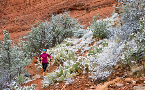
Photo from Runner's World - not me running
One of my sister shows at E.W. Scripps is called “Right This Minute.”  While the show has nothing to do with me, except that their social media person and I are planning to share ideas sometime soon, the name of the show is kind of how I live my life.

Yup, I’m the “Right This Minute” girl – especially now that I have a car.

 Last night, I was looking through the January issue of Runner’s World and saw this amazing photo.  It’s their Rave Run of the month. Gorgeous, right? And check out the caption “Snow-capped cacti and the red hue from the nearby sandstone mesa make for a fleeting yet dramatic spectacle as daylight hits the Mescal Trail.”

Now normal people would look at this, think it’s nice and turn the page. Me? I’m not normal. There is no page turning for this chick. Remember…”I’m the “Right This Minute Girl.”

In seconds, I’m on Google thinking, “Cacti? I just moved to Arizona – the land of Cacti. Where is this heavenly place with snow-capped stuff?”


A couple Google searches later, I find it. It’s in Sedona.

For those of you who haven’t been to Phoenix, that’s a little less than 2 hours away.  I sketch out the route to the trail in case my GPS fails me, dig out my gloves and warm running hat, fill my camel pack with water, and set my alarm for 5:30 a.m.

My goal is to be in Sedona by 7:30 the next morning. Forget just looking at the Mescal Trail in the magazine, I was going to check it out in person.

MORE PHOTOS OF THE MESCAL TRAIL

If you are planning to go, there is a hard way and an easy way to get to the trail. The easy way is to go to Sedona and look for Dead Man’s pass. The hard way is to follow the instructions I found on the internet that say: “From the "Y", proceed west on State Route 89A three miles and make a right turn on Dry Creek Road. Follow Dry Creek Road to the end (about 3 miles). Turn right on Long Canyon Road and proceed 0.6 miles to the parking on the left." I took the hard way.


I found the parking area okay, but there were no signs for the Mescal Trail. Thinking I was lost, I parked and started walking the trail to Dead Man’s Pass for the fun of it. At 7:30 a.m. I was the only person in the parking lot and the trail was covered with frost -- exactly like the magazine promised.

About a half mile along Dead Man’s Pass I saw a little sign leading up a hill that read, “Mescal Trail.” Happy day! I accidentally found it.

Compared to the “Dead Man’s Pass” trail, the Mescal route was much less traveled – but there was a vague path. Following the 2.6 mile path, all I heard was my crunching shoes on the frost.

Total peace and quiet (except for me). And so worth the drive – right this minute.

Monday, September 24, 2012

Crawling over Flatiron Mountain (also known as "Ow...my legs")


I have one word for Flatiron Mountain: KILLER. 

Flatiron Mountain is about an hour out of Phoenix by Mesa.  I had heard about this place from my long-time friend Dave who works at the TV station I was at in Sacramento. He had climbed it in the past and when he learned I was moving to Phoenix told me I had to check it out if I got the chance.  He also told me it was hard. Naturally, I didn't believe him.  I assumed he thought I was wimpy or something.

Little did I know he was right and my legs would hate me for three days after climbing the thing.
So here's the scoop in case you want to try it yourself -- because you know, misery loves company and right now I'm needing the company.

The Siphon Draw Trail at Flatiron starts at Lost Dutchman State Park and it is 6 miles long  – which sounds like nothing until you actually do it.  This is because, the higher you climb, the harder it gets – and my friend and I also went when it was 106 degrees.  Yes, it was hot.  Way too hot to be climbing a mountain, but whatever.

If you go, at first you are going to think I’m a wuss because the first mile of the trail is easy.  It’s well-maintained and marked.  But keep going.  The farther you walk up the trail, the more rugged the path gets. 

Soon the dirt path disappears and is replaced with small loose rocks and the higher you climb, the more narrow and rough the path gets.   There are giant boulders to climb over and a large smooth stone basin which probably has water in it part of the year, but was completely dry when we went in September. By the time you get to the basin area, you've already reached a 1,000 foot elevation gain.

From there, the trail (if you could call it that), leads towards Flatiron, which is the flat plateau on the top of the Superstition Mountain. It's another 2,000 foot elevation from the basin to the top and the brochure recommends that only experienced hikers in good shape should attempt it.

I was considering to do this mountain alone, but was glad I went with a friend.  The path is kind of marked (you have to look for faded blue spray painted marks on the boulders), but even with that, we got lost and made up our own route for part of the way. 
Then there’s the climbing. This is what was challenging for me. I’ve hiked, but never actually had to climb and pull myself over giant rocks before.  Of course, I’m wearing normal sneakers and not hiking shoes as I had no idea the climb would be so intense.   And then just when you think you’re done and can see the top, there is a 12-foot vertical rock wall. 
I admit, I didn't get that far. I had to wimp out about 10 minutes before reaching the top. 

This is because just before giant vertical wall was a slightly smaller (yet, still too big for me) boulder area and I couldn’t pull myself over it.  Yes, the mountain defeated me and if they hidden cameras in the area, I would totally be on the blooper reel as I am not a graceful climber.  I'm more like the people on that show "Wipe Out" with arms flailing everywhere and hanging on any which way possible.

But what I really needed to make it to the top was two people: One to pull my arms and someone behind me to push my butt up from behind -- or maybe catch me as I slid back down.

My friend (who went on ahead) tells me that if I would have been able to scale the 12-foot rock wall, I would have been at the top of the mountain. Sigh...so close, but not close enough.
I don’t have any regrets though. I was exhausted just getting to where I got to, and going down was just as hard as going up. 

You see, going up you can use your hands to claw and clutch your way up, but going down, there is no clutching.  There is only scary sliding down on your butt and hoping your feet find a little hook in the rock to stop you. I swear, I crab-crawled my way down the mountain and was glad I had my biking gloves with me or else my hands would have been shredded.


So will I do it again? Yes. But here’s what I would do differently:
        
-- Bring more water
        
-- Start earlier and not at 11 a.m. when it’s super hot
  
-    -- Do more upper body training so I can make it over the rock wall

- Buy some sort of repellent to deter the giant wasps that live up there.

   If you want to go, Flatiron Mountain is in Maricopa County in the state of Arizona (AZ). It climbs to 1,693 feet (516.03 meters) above sea level and is located at latitude - longitude coordinates of N 33.570037 and W -112.832399.

Sunday, September 9, 2012

Climb every mountain – in the Phoenix area

I’m not exactly Maria from the “Sound of Music,” but lately I feel like I’ve been climbing every mountain I can find around Phoenix.

Part of the reason is because I am totally loving the Arizona landscape. Who would have thought it would be so beautiful here? Before I moved to the area, all people told me was that it was hot and desert-like.
 

Yes, it’s hot. Extremely hot, but the desert is interesting.

But I digress. The real reason I’m climbing the mountains in the area is because they are there.

CHECK OUT MORE PHOTOS HERE

PINNACLE PEAK - SO CLOSE TO HOME


My first one and the one that got me hooked was Pinnacle Peak.

This little guy is located just outside of Phoenix and I did it twice in one day. The first time I ran/walked up and then because it was so beautiful, I did it again, but the second time I brought my iPhone so I could take photos on the way.

It’s absolutely gorgeous and one of my favorite ones in the area so far. The hike is only 1.75 miles (one way) and you climb approximately 1,300 feet with the highest point of the trail at 2,889 feet. It’s not a loop trail so you go down the same way you go up.

These photos were taken in the fall after the heat of the summer, but one of the reasons I love this trail so much is that the landscape changes so much throughout the year.  I did this one almost every week so was able to see the spring flowers bloom in March/April, the green of the cactus during May and June and then the browns of the fall.

One of the pluses of this trail is that it’s well-marked so you won’t get lost. They also have guides that walk up the path an hour before they close (at sunset) to make sure everyone is off the peak – so no chance of being left behind.

The only downside of Pinnacle Peak is that it can be crowded on the weekend.

I tried it one Sunday morning and even at 6:30 a.m., it was crazy busy. It’s less busy during the week.

Want to go for a hike? It’s located at 26802 N. 102nd Way in Scottsdale.


CAMELBACK MOUNTAIN

Every day on my way to work, I drive past this amazing red mountain. Turns out this is the infamous Camelback Mountain. It's really only famous in Phoenix as people always want to know if you've climbed it.

I have climbed it but only the Cholla Trail side.  There is a reason for this.  I was going to climb the Echo Canyon side which they say is shorter, but steeper, however, the week before my set date to climb a bunch of killer bees attacked a group of hikers and one of them died.  He fell off the side of the mountain. His buddies were just badly stung.

Now I know I hung out with the Bee Whisperer this summer in Carmel Valley, but those were honey bees. These were African “killer” bees. I wasn’t sure I was ready to mess those big boys.

So I did the Cholla side, which some say is a little harder because you don’t have any ropes to pull yourself up. You have to hoist yourself up over the rocks.  In fact, the last 1/8 of a mile to the summit is all rock scrambling.

So here’s the scoop with this hike. You have to go early. Really early. Like just as the sun is getting up early.  Otherwise you are not going to get parking in the area and you’ll not only be crawling over rocks, but people in your quest to get to the top.

What is fun though is that while I think this climb is harder than Pinnacle Peak, dogs can make it up to the top.

 If you want to try it, the Cholla Trailhead is located at the end of Cholla Lane, which is off of Invergordon Street (N. 64th Street).  It’s 3.5 miles round trip from trailhead to the top and back.

Sunday, September 2, 2012

Red Rocks and Drumming in Sedona (Vortex Tours)


Rahelio - I had to steal this from his
website as my camera didn't work.
If you visit Phoenix, then you have to take a daytrip to Sedona.  It’s gorgeous – and very red. 

The rocks are red, the dirt is red and even the buildings are red. People told me about the redness before I went, but you need to see them to believe it -- especially at sunrise or sunset. It's breathtaking.

But what Sedona is really famous for is their spiritual vortexes which are supposed to enlighten, renew and empower you. 

When I found out about the Sedona vortexes, I did a little bit of research (because you know I had to check them out as they sounded very "Dr. Who-ish") and there are number of tour groups that will take you there.  One of the most popular ones are these pink jeeps.  But here's my question:  why take a pink jeep when you can have a shamanic guide, who also does Sedona sweat lodge sessions, take you to the vortex location?
Yup, that’s right.  You know me. I can’t do the normal tour.  I have to do the weird one….and I would do it again in a heartbeat.


HE HAD ME AT “HELLO”
I found Rahelio and his  mystic tour by random chance on the internet.  He doesn’t have a fancy website (http://rahelio.homestead.com), but on the site he said his Sedona Vortex tours were for those “who might be awakening in consciousness or who are on a spiritual quest.”  On the tour, he said people may experience a powerfully transformative encounter with the mystical presence of a sacred land.

Am I on a spiritual quest? I don’t know. Maybe?

So I called him up, and instead of answering with a fancy company name, he answered with a simple “hello.”
I was sold.

DRUMMING AND FLIP FLOPS
When I called up Rahelio, I wasn’t sure what to expect.  He told me to meet him outside this organic grocery story around 3:30 p.m. because he was doing a sweat lodge session in Sedona the night before and needed to sleep in. 

I hung up thinking this guy is really sounding like my type of tour guide -- not fancy and likes to sleep in. Works for me.  Plus, I figured this way I could take my time getting there.  In my mind I imagined us and our little group hiking through red rock country for two hours in search of the sacred vortexes.  I would get this fantastic workout AND be spiritually enlightened. The ultimate in multi-tasking -- and you know how I love to multi-task.

Rahelio drove up exactly at 3:30 and he was in shorts and flip flops.  It was then I realized, we would not be hiking very far.  But what would we be doing? The answer: drumming. Yes, drumming – and it was more cool than I could have imagined, and something I had never done before. 
GETTING INTIMATE WITH THE SPIRITUAL VORTEXES
Rahelio drove our little group of 5 up the mountain to one of the vortex areas.  He grabbed mats from the back of his truck, his drum and ceremonial flute and then led us to this gorgeous area overlooking the red rocks.  I have no pictures of this as my iphone crapped out on me that day, so you’ll have to take my word that it was amazing.

He laid out the mats in a row and told us to sit or lie down on them. He then let us experience the energy of the vortex as he drummed, chanted and sung about Mother Earth, Mayan prophecy and the shamanic teachings he’s learned over the years. 

It was a relaxing and inspiring journey that I never expected. Laying on earth, the experience with the vortexes was much more intimate that it would have been on a jeep tour. I'm not sure how enlightened I was, but I’m glad it turned out the way it did and that I met Rahelio.

I could go hiking any time, but how often would I get to hang with a shamanic guide and listen to drumming as the sun set over the Sedona mountains?

I’m already thinking that next time, I may try his sweat lodge encounter the next time I go to Sedona.